|
imran
|
 |
« Reply #6 on: December 22, 2015, 05:36:44 AM » |
|
7. Storm Cell Over the Southern Appalachian Mountains This storm cell photo was taken from NASAs high-altitude ER-2 aircraft on May 23, 2014, during a study aimed at gaining a better understanding of precipitation over mountainous terrain. This storm cell photo was taken from NASAs high-altitude ER-2 aircraft on May 23, 2014, during a study aimed at gaining a better understanding of precipitation over mountainous terrain.
|
|
|
|
|
|
imran
|
|
« Reply #7 on: December 22, 2015, 05:37:14 AM » |
|
8. An Astronauts View from Space NASA astronaut Reid Wiseman tweeted this photo from the International Space Station on Tuesday morning, Sept. 2, 2014. My favorite views from #space just past #sunrise over the ocean, the Expedition 40 astronaut tweeted. NASA astronaut Reid Wiseman tweeted this photo from the International Space Station on Tuesday morning, Sept. 2, 2014. My favorite views from #space just past #sunrise over the ocean, the Expedition 40 astronaut tweeted.
|
|
|
|
|
|
imran
|
|
« Reply #8 on: December 22, 2015, 05:37:35 AM » |
|
9. Venice Lagoon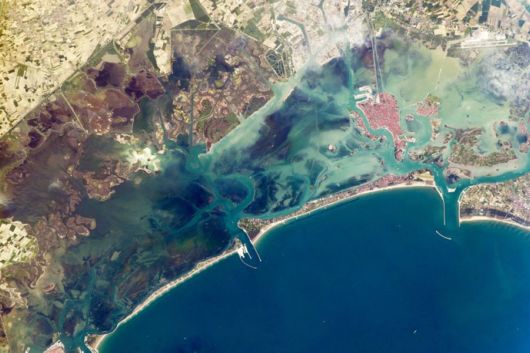 A narrow barrier island protects the Lagoon of Venice from storm waves in the northern Adriatic Sea, and breakwaters protect inlets to the lagoon. Red tiles on the roofs of Venice contrast with the grays of the sister city of Mestre, and the cities are joined by a prominent causeway. What appears to be another causeway joining the island to the airport (top right) is actually the combined wakes of many boats and water taxis shuttling between them. Small, bright agricultural fields on well-drained soils (top left) contrast with the darker vegetation of back-bay swamps, where fishing is a popular pastime. A narrow barrier island protects the Lagoon of Venice from storm waves in the northern Adriatic Sea, and breakwaters protect inlets to the lagoon. Red tiles on the roofs of Venice contrast with the grays of the sister city of Mestre, and the cities are joined by a prominent causeway. What appears to be another causeway joining the island to the airport (top right) is actually the combined wakes of many boats and water taxis shuttling between them. Small, bright agricultural fields on well-drained soils (top left) contrast with the darker vegetation of back-bay swamps, where fishing is a popular pastime.
|
|
|
|
|
|
imran
|
|
« Reply #9 on: December 22, 2015, 05:37:57 AM » |
|
10. Earth at Night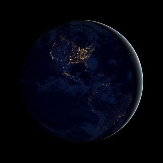 This new global view of Earths city lights is a composite assembled from data acquired by the Suomi National Polar-orbiting Partnership (NPP) satellite. The data was acquired over nine days in April 2012 and 13 days in October 2012. It took 312 orbits to get a clear shot of every parcel of Earths land surface and islands. This new global view of Earths city lights is a composite assembled from data acquired by the Suomi National Polar-orbiting Partnership (NPP) satellite. The data was acquired over nine days in April 2012 and 13 days in October 2012. It took 312 orbits to get a clear shot of every parcel of Earths land surface and islands.
|
|
|
|
|
|
imran
|
|
« Reply #10 on: December 22, 2015, 05:38:31 AM » |
|
11. Iberian Peninsula at Night One of the Expedition 40 crew members aboard the International Space Station recorded this early evening photo of the entire Iberian Peninsula (Spain and Portugal) on July 26, 2014. Part of France can be seen at the top of the image and the Strait of Gibraltar is visible at bottom, with a very small portion of Morocco visible near the lower right corner. One of the Expedition 40 crew members aboard the International Space Station recorded this early evening photo of the entire Iberian Peninsula (Spain and Portugal) on July 26, 2014. Part of France can be seen at the top of the image and the Strait of Gibraltar is visible at bottom, with a very small portion of Morocco visible near the lower right corner.
|
|
|
|
|
|
imran
|
|
« Reply #11 on: December 22, 2015, 05:39:00 AM » |
|
12. Windswept Valleys in Northern Africa Expedition 40 Flight Engineer Alexander Gerst of the European Space Agency posted this photograph of windswept valleys in Northern Africa, taken from the International Space Station, to social media on July 6, 2014.Go to The NEXT Page for More Pictures >>> Expedition 40 Flight Engineer Alexander Gerst of the European Space Agency posted this photograph of windswept valleys in Northern Africa, taken from the International Space Station, to social media on July 6, 2014.Go to The NEXT Page for More Pictures >>>
|
|
|
|
|
|
 IMAGE CORNER
